Washington, D.C. — While the polar vortex has dominated headlines in recent weeks, federal forecasters say another powerful climate driver remains firmly in control of winter weather across the United States. Scientists with the National Oceanic and Atmospheric Administration’s Climate Prediction Center (CPC) have confirmed that La Niña is expected to persist through the remainder of the 2025–26 winter season, continuing to influence temperature, precipitation, and snowfall patterns nationwide.
According to the CPC’s monthly outlook released Thursday, Dec. 11, the La Niña pattern that developed in October remains active and is forecast to shape weather conditions through December, January, and February, the core months of meteorological winter.
La Niña and the polar vortex both influencing winter
Forecasters say La Niña and the polar vortex have been working in tandem this winter, each playing a different role in how cold air behaves across North America.
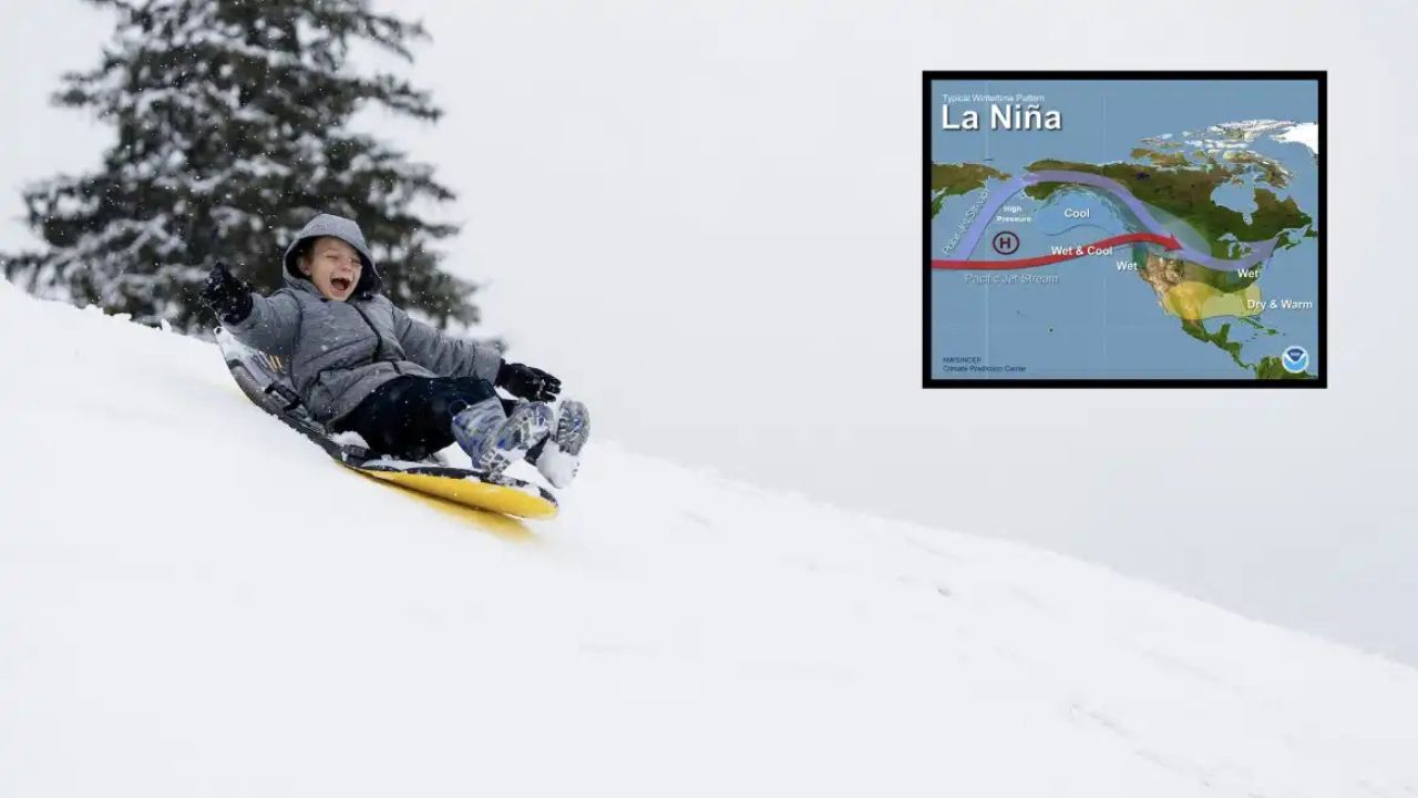
The polar vortex largely determines how much Arctic air is released southward, while La Niña influences where that cold air ultimately settles. In recent weeks, that interaction has produced sharp temperature swings and periods of intense cold across parts of the country.
As of mid-December, meteorologists say a lobe of the polar vortex is poised to send a surge of extremely cold air into the central and eastern United States. That blast, however, may not last indefinitely.
Forecasters expect the vortex to retreat later in December, allowing La Niña’s more familiar winter pattern to reassert itself into late December and January.
What exactly is La Niña?
La Niña is part of a natural climate cycle known as the El Niño–Southern Oscillation, or ENSO. This cycle reflects changes in ocean temperatures along the equator in the tropical Pacific Ocean, which in turn affect global weather patterns.
La Niña occurs when sea surface temperatures in that region are cooler than average. It is essentially the opposite phase of El Niño, which is marked by warmer-than-average Pacific waters sustained over several months.
Between those two extremes is ENSO-neutral, a phase when neither La Niña nor El Niño dominates.

Despite often being less talked about than El Niño, La Niña is considered one of the most influential drivers of U.S. winter weather, particularly from late fall through early spring.
La Niña expected to persist through winter 2025–26
CPC scientists say current data strongly supports La Niña’s continued influence well into early 2026.
“The latest CPC seasonal outlooks show La Niña’s telltale influence on precipitation anomalies through at least February–April,” said Michelle L’Heureux, a CPC climate scientist, in a Dec. 10 email.
When La Niña first formed in October, federal forecasters anticipated it would last through February, and updated outlooks have remained consistent with that projection.
L’Heureux noted that La Niña typically brings drier conditions across the southern tier of the United States, while areas farther north tend to see wetter-than-average weather.
Snowier winter favored in northern regions
Those precipitation patterns have direct implications for snowfall.
Under La Niña, forecasters expect above-average snowfall across parts of the Pacific Northwest, northern Rockies, Great Lakes region, and interior Northeast. Several of these areas have already experienced frequent snow events this season, consistent with La Niña-driven expectations.
Meanwhile, much of the southern U.S. is more likely to remain drier overall, though individual storms can still bring short-lived winter weather.
A return to a more typical La Niña pattern
Once the polar vortex relaxes later this month, meteorologists expect La Niña to become the primary steering mechanism for U.S. winter weather.
“This should favor a return to the more normal pattern of La Niña,” said Paul Pastelok, a long-range forecaster with AccuWeather.
Read Also: Snow Could Hit Massachusetts Sunday — the Patriots-Bills Game May Be Played in a Snowfall
That pattern typically features storm tracks shifting northward, colder-than-average conditions across the northern states, and fewer widespread winter storms across the southern tier.
When will La Niña fade?
Although La Niña is expected to remain influential for the rest of winter, forecasters do see an end on the horizon.
“At this point we favor a transition to ENSO-neutral during the January–March 2026 season,” L’Heureux said.
Even after Pacific sea surface temperatures return closer to average, La Niña’s effects may not disappear immediately.
According to the CPC, lingering impacts could continue into early Northern Hemisphere spring 2026, especially in long-range precipitation and temperature trends.
Implications beyond winter weather
The eventual shift away from La Niña could have implications beyond winter.
Forecasters note that if El Niño were to develop later in 2026, it could help suppress Atlantic hurricane activity next year. El Niño typically increases wind shear over the Atlantic, making it harder for tropical systems to strengthen.

For now, however, La Niña remains the dominant force.
What this means for the rest of winter
With La Niña firmly in place, meteorologists say Americans should expect continued regional contrasts for the remainder of winter — colder and snowier conditions across the northern states, and relatively drier patterns farther south.
Short-term extremes driven by the polar vortex may still occur, but La Niña is expected to guide the broader weather pattern through the heart of the season.
As forecasters continue to monitor both systems, residents are encouraged to stay aware of regional forecasts and prepare for rapid weather changes that often accompany La Niña winters.
How has La Niña affected weather where you live so far this winter? Share your local experience in the comments below.