Louisville, Kentucky — Kentucky is bracing for a stretch of bone-chilling winter weather as a weakened polar vortex allows a surge of Arctic air to plunge southward into the central and eastern United States, driving temperatures well below normal and pushing wind chills into dangerous territory.
Meteorologists say the cold air mass building over western Canada is now breaking loose and heading straight into the region, setting the stage for one of the coldest periods of the season so far across the commonwealth.
Arctic air surging south like a “wrecking ball”
The incoming cold has drawn attention from weather experts nationwide.
“The frigid air will be barreling into the central and eastern United States this coming weekend like a wrecking ball,” said Weather Trader meteorologist Ryan Maue in a post.
Maue described the setup as a “textbook polar vortex mega-dump of western Canadian cold,” signaling a classic scenario where Arctic air is displaced far from its usual position near the North Pole.
This type of pattern allows cold air to move south with little resistance, spreading rapidly across the Midwest, Ohio Valley, and into Kentucky.
Kentucky already primed for extreme cold
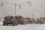
Kentucky has already seen multiple rounds of snow and below-normal temperatures in recent weeks, which has helped set the stage for this Arctic blast.
With cold ground conditions already in place, forecasters say incoming temperatures will feel even harsher, especially when combined with gusty winds expected over the weekend.
Despite the severity of the cold, meteorologists stress that this outbreak is not expected to last for weeks, offering at least some relief for residents who struggle with extreme winter weather.
How cold could it get in Louisville?
According to the Courier Journal, Louisville could see additional snow chances in the coming days, along with temperatures dropping into the single digits and low teens.
Wind chills could make conditions feel even colder, potentially falling to around -8 degrees, especially during overnight and early morning hours.
Such conditions increase the risk of frostbite and hypothermia, particularly for those spending extended time outdoors or lacking adequate heating.
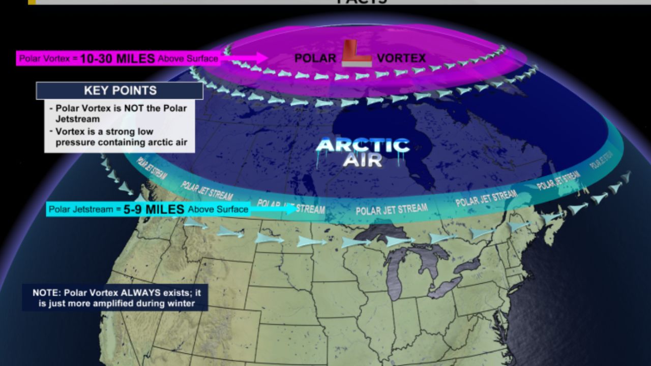
What exactly is the polar vortex?
The polar vortex is a large, swirling pool of extremely cold air that normally spins high in the atmosphere over the Arctic, according to the National Weather Service.
Located in the stratosphere, the vortex usually acts as a containment system, keeping the coldest air locked near the North Pole. When the vortex is strong, winter conditions in the U.S. tend to be milder.
However, when the polar vortex weakens or becomes disrupted, lobes of Arctic air can break free and travel southward — bringing sharper cold, snow, and extreme wind chills to parts of the United States.
Contrary to popular belief, a weaker polar vortex often leads to harsher winter weather across the U.S., not milder conditions.
La Niña also playing a role
While the polar vortex is driving the immediate cold outbreak, forecasters say La Niña is also shaping the broader winter pattern.
La Niña is part of the El Niño–Southern Oscillation (ENSO), a natural climate cycle tied to ocean temperatures in the tropical Pacific. During La Niña, cooler-than-average sea surface temperatures influence atmospheric circulation worldwide.
Read Also: Snow Band Stretches From Montana to Pennsylvania Through Sunday, Impacting More Than a Dozen States
In the United States, La Niña often favors colder and snowier conditions across the northern and central regions during late fall and winter, while the southern tier tends to be drier.
Meteorologists say that once the polar vortex retreats northward later this month, La Niña is expected to regain dominance, bringing a return to more typical winter temperature swings.
Cold blast expected to be short-lived
Despite the intensity of the Arctic air, forecasters say the worst of the cold should be relatively brief.
Long-range outlooks suggest temperatures will moderate later in the month and into the new year, as the polar vortex recenters over the Arctic and loses its grip on the central and eastern U.S.
While cold snaps will still be possible — typical for winter — they are expected to be less extreme than the upcoming outbreak.

What residents should know
As the cold settles in, officials urge Kentuckians to take precautions:
- Dress in layers, covering exposed skin
- Limit time outdoors, especially during overnight and early morning hours
- Check on elderly neighbors and those without reliable heat
- Protect pipes from freezing during the coldest nights
Travelers should also be mindful of icy conditions if snow develops alongside the cold air.
For now, the message from forecasters is clear: Kentucky is in for a sharp but temporary Arctic punch, driven by a weakened polar vortex — with gradual relief likely as winter patterns rebalance.
How cold has it gotten where you live in Kentucky? Share your local conditions and how you’re preparing for the freeze in the comments below.